It's an odd fact that many homeschool families are strong on history, but weak on geography. Geography and history are sister disciplines, each shedding light on the other and necessary for a complete picture of either. The folks at Knowledge Quest have been bridging that gap for some time now, weaving the study of history with the study of the places history happened.
Map Trek: The Complete Collection is one of the best products they've developed. Both a series of history/geography lesson plans and an historical atlas, this book may be used over and over with students of all ages. In fact, many parents have testified to learning as much (or nearly as much) as their kids as they present the material and help their children conduct research.
How Does This Work?
There's are two books here, both softcover: the atlas and map book, and the outlines/student activity book
Five sections in the Atlas cover five major divisions of history: the ancient times, the Middle Ages, the New World, the modern world, and the United States. Each section contains several maps covering major places and events of the period in question; there are also complete world and continent maps, each with drawing grids to assist copying.
All maps in the Atlas are in color, and cover everything from the Viking expansion, to the division of Ireland, to the 12 tribes of Israel. These are historical atlas-style maps for the most part, complete with trade route lines, sites of major battles, former boundaries, etc. Kids can study the maps themselves, and add to them with their own markings; the printable maps on the CD-ROM are outline versions of the complete maps in the book.
Lesson plans relate directly to the maps, are laid out chronologically, and are divided into three grade levels. Level A covers grades 1-4, Level B covers grades 5-8, and Level C covers grades 9-12. Assignments for each level are age appropriate; you can either have kids work from content you provide, or guide them in their own research. Grade guidelines are not rigid; if your 6th grader is behind, you can have them do the Level A work, and vice versa.
These maps and lesson plans are laid out in chronological order, so you can use them side-by-side with any chronological history program. In fact, because the maps show the world past and present, they should be used in this way; again, geography and history are dependent studies, and Map Trek bridges the gap.
We strongly advise printing the maps off the CD-ROM rather than having kids draw in the book itself. Children can use this over multiple years, especially if you follow the grade level assignments in the lesson plans, but only if they have fresh maps to work with. Repeated use of the same maps, rather than proving redundant, actually reinforces for long-term memory what students have learned.
Our Honest Opinion
Because geography requires lots of memorization and repetition if you expect to cement content in kids' minds, we like this program; because geography and history are so interrelated yet so often separated, we really like this program; because geography isn't something most parents remember too well (mainly due to its insufficient coverage in schools), we really, really like this intuitive and parent-friendly program.
You can use Map Trek by itself, but that wouldn't unlock its complete potential. Anchoring these exercises to a solid history program will both highlight the essential unity of the two subjects, and provide context for the map work. This is an excellent geography supplement course that we recommend very highly, though it is important to note that the maps here are historically based; for physical world geography, we recommend World Physical Geography by Barbara Runkle.
Here's a brief overview of the program:
- Historical maps that will help you navigate through history studies.
- Accurate maps that show what the world was like THEN and NOW.
- Attractive maps that you and your children will be proud to display.
- Lesson plans that will show you what to do with them each week.
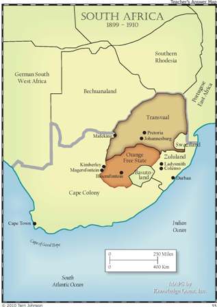
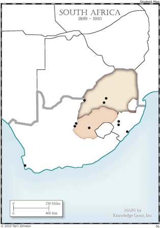
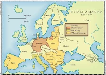
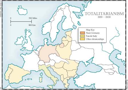
- An unlabeled student map for your child to color in and label. Notice a few key features on this map. There is a slight color shading on the ocean/water areas to help your child determine which parts of the map are land and which are water. BUT the shading is minimal so as to not interfere with his creative coloring process.
- Lesson Plans to help you know what to assign to each of your children at their various stages of learning. There are lesson plans included for all 350+ outline maps and are broken down into 3 levels - Level A (grades 1-4), Level B (grades 5-8) and Level C (grades 9-12).
Here are two more maps for you to download to help you make your decision.
This is what you get:
- 276 Full-color teacher answer maps.
- 270 Blank outline maps for the student.
- Instructions for how to use these maps
- 15 Grid Maps
- 10 Blank Grids
- Lesson Plans
- Glossary of terms
- 3 Bonus Map Sets
- 650 total pages
Review by C. Hollis Crossman
C. Hollis Crossman used to be a child. Now he's a husband and father who loves church, good food, and weird stuff. He might be a mythical creature, but he's definitely not a centaur. Read more of his reviews
here.
Did you find this review helpful?